Purpose and Scope
Navigating and Using the Map
Feedback
Purpose and Scope
What is the purpose of this web page?
The IDEQ Waste Management and Remediation Division Facility Mapper (Facility Mapper) serves the general public, local governments, environmental consultants and others interested in finding the location and additional details regarding remediation sites and facilities managed by regulatory programs within the Waste Remediation and Management Division. In addition the Facility Mapper provides information on which remediation sites across the state have had activity and use limitations (AUL) implemented on their property in the form of Environmental Covenants.
The Facility Mapper displays remediation sites and facilities in a web-accessible map view and allows for powerful keyword searching and pan and zoom navigation to find sites of interest. Once located, the Facility Mapper provides additional feature info about each site. The feature information includes a list of programs implemented at a given site as well as basic program identification and contact information. The Facility Mapper also provides direct access to Environmental Covenant documents. The Advanced Search feature of the Facility Mapper allows the user to search the database of facilities, view facility information, create lists of search results and, if desired download a file of lists created that can be imported into a spreadsheet application. Similarly, The Radius Search feature finds all sites within a selected radius.
Does the Facility Mapper warrant or guarantee accuracy or comprehensiveness of the information provided?
No. The Facility Mapper is provided for informational purposes only. While IDEQ makes every effort to assure that the information provided is accurate, IDEQ makes no guarantees or warranty of the accuracy or comprehensiveness of the information provided.
Which sites are included on this web page?
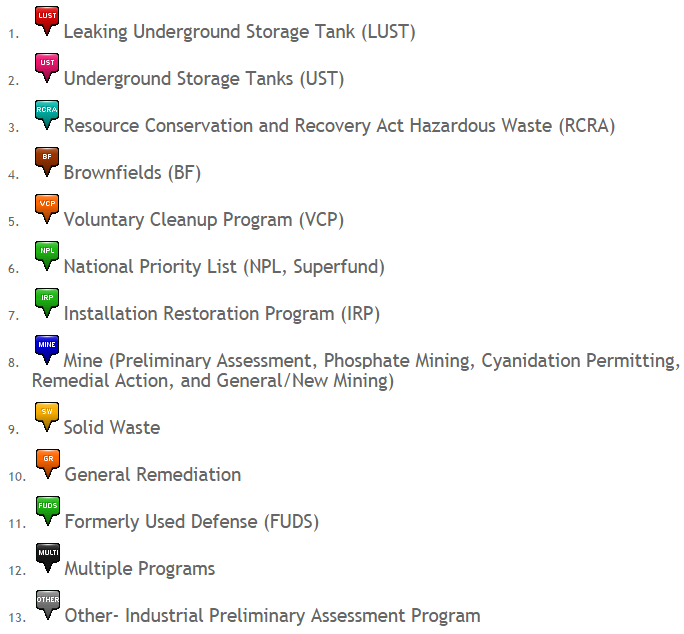
The IDEQ Waste Management and Remediation Division oversees various sites and facilities which generate or manage wastes or which have released wastes into the environment which require remediation. The IDEQ Waste Management and Remediation Division web page provides access to additional information on the activities in the Division. The IDEQ Waste Management & Remediation Division categorizes sites into various regulatory programs. The programs included within the Facility Mapper include the following:
 Are all the sites actually displayed on the map?
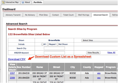
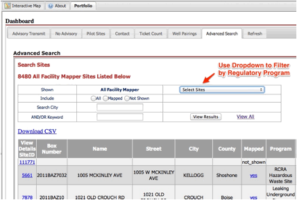
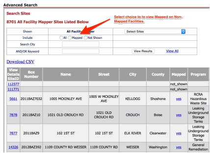
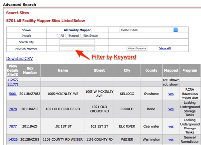
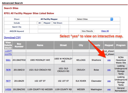
Over 8,000 Waste Management and Remediation Division sites and facilities exist. An attempt was made to map all the sites and facilities but DEQ records do not provide accurate location information for some sites, so approximately 600 sites have not been mapped. These unmapped sites are listed, along with the same feature information available for mapped sites. To view a listing of the sites not shown on the map, use the Advanced Search tool accessible via the link found to the right of the Location and Filter search bars. Unmapped sites can be searched using a keyword and program details can be found for a site of interest by clicking the details link. As more accurate locational information is obtained, the sites will become viewable on the map. See the Advanced Search Help page for search details.
How do I search the map to find sites?
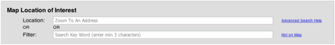
The Facility Mapper provides two search tools for finding sites, the Standard Search tool found above the map on the Home Page and the Advanced Search tool found by clicking the link located to the right of the Standard Search tool. The Standard Search tool is a powerful means for keyword searching for individual sites, using either Location keywords or Filter keywords. The Location and Filter search options are independent of each other. Location keyword searching can locate sites by address or city keywords. Filter keyword searching can use keywords such as site name or parts of a name, or with two keywords, such as site name AND city for a more refined search. Entering the keyword "covenant" into the Filter search bar will display a list of all sites and their address, for which Environmental Covenants have been issued. Select the site of interest to navigate to the site. Once at the site click, on the environmental covenant tab to view the general types of restrictions implemented in the covenant. Click on the view link to access the actual recorded covenant. See Help for additional details on keyword searching.
The Advanced Search tool provides additional methods to find sites or groups of sites as well as save the results of searches. In addition to the standard filters, sites can be searched based on the regulatory program in which they are involved and whether or not their locational information is sufficient to show them on the map view or not. Once a list is created the detailed information for sites in the list can be viewed. The lists themselves can be downloaded to a CSV file which can be imported into a spreadsheet application and printed. Further, a Radius Search feature allows for finding and downloading sites within a specified radial distance. See Help for details on the use of these tools.
Navigating and Using the Map
How do I navigate the map view?
In addition to keyword searching, various navigation tools allow users to, for example, pan, zoom, measure areas and perform other map navigation functions. These tools exist in the upper left side of the map just above the map. Placing the mouse over an icon presents a description of the function of that tool. Clicking on the tool enables that function.
In any given map view, sites are shown as colored and labeled icons. The icons describe the DEQ program or programs involved with a site. The color legend found below the map describes the DEQ program associated with each icon. The icon itself is also labeled with the acronym for that program. Certain icons are associated with multiple programs. The LUST icon describes participation of both the LUST and UST programs. The MULTI icon reflects the involvement of more than one program, apart from UST/LUST, such as the UST and RCRA programs. Finally, the OTHER icon describes sites involved with the Industrial Preliminary Assessment program. As one hovers over a given site icon the name of that site or facility appears.
When I find my site of interest, how can I see the available details about the site?
With the "pan" tool selected from the upper left corner, select your site of interest by left-clicking on the icon with the mouse. Doing so displays an "i" button on the selected site and shows site details in the Feature Info panel below the map.
The Feature Info panel contains several tabs along the upper left of the frame which provide additional site information. The Programs tab provides information on which Waste Management and Remediation Division programs have had involvement with the site. The program is listed along with a program specific ID number and, where appropriate and available, an indication of the status of the site in that program. The status is commonly related to sites where remediation is or has taken place, such as the Voluntary Cleanup Program or the Leaking Underground Storage Tank Program. Clicking on the link for a given program takes you to the program"s DEQ webpage, where available, and provides an additional source of program information. For the Underground Storage Tank Program, clicking on the program link at a site will take the user to the IDEQ UST-LUST database detailed information for that particular facility.
Selecting the Contact IDEQ tab provides the user with IDEQ staff contact person information for all the programs involved at the site as well as a general IDEQ phone number for the IDEQ Regional Office where the site is located.
The final tab which occurs for selected sites where remediation took place is entitled Environmental Covenant. An environmental covenant is a legal instrument recorded on real property and governed by the Uniform Environmental Covenants Act (UECA), Chapter 30, Title 55, Idaho Code. An environmental covenant is commonly used as a component of a risk-based cleanup to control the potential risks posed by residual contamination, protect the integrity of the cleanup action, and assure continued protection of human health and the environment. See our Environmental Covenant web page for additional details.
When Environmental Covenants have been recorded for sites, this tab provides general information regarding the activity and use limitations required by the Environmental Covenant and provides access to the actual document.
I have a question about a site, how do I contact you?
Navigate to the site, click on the site and in the Feature Info section under the map, go to the Contact IDEQ tab. Here you find the Program Managers for the site, listed with phone number and email. You can click on the email address to launch an email to the manager. The email subject line will refer to the site, so all you need to do is enter your question or comment.
Also, if specific information regarding a site is desired a public information request can be submitted to IDEQ. The Facility Mapper facilitates this by providing a link in the Map View directly to the IDEQ public information request online submittal form.
How do I switch between satellite view and street map view?
The Facility Mapper defaults to a hybrid satellite imagery view which shows the terrain and streets. However, you can switch to the standard street view and toggle between street and satellite view, by selecting the blue plus sign on the top right side of the map and then clicking the appropriate radio button for the view desired.
Feedback
How can I leave you some feedback?
We very much appreciate your feedback as we strive to improve our map and site. Please click here to leave your feedback.
Additional Questions
Contact us if you have additional questions Send email.